2004 Indian Ocean earthquake and tsunami
- Persons:
- 2List of persons
- Events:
- 71List
- Monuments:
- 0
- Places:
- 0
- Cemeteries:
- 0
- Date:
- 26.12.2004
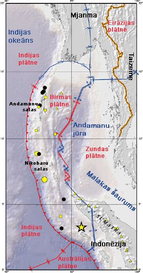
On 26 December 2004, at 07:58:53 local time (UTC+7), a major earthquake with a magnitude of 9.2–9.3 Mw struck with an epicentre off the west coast of Aceh in northern Sumatra, Indonesia. The undersea megathrust earthquake, known by the scientific community as the Sumatra–Andaman earthquake, was caused by a rupture along the fault between the Burma plate and the Indian plate, and reached a Mercalli intensity of IX in some areas.
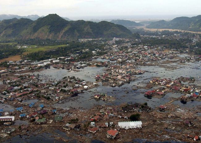
A massive tsunami with waves up to 30 m (100 ft) high, known as the Boxing Day Tsunami after the Boxing Day holiday, or as the Asian Tsunami, devastated communities along the surrounding coasts of the Indian Ocean, killing an estimated 227,898 people in 14 countries, violently in Aceh (Indonesia), and severely in Sri Lanka, Tamil Nadu (India), and Khao Lak (Thailand). The direct results caused major disruptions to living conditions and commerce in coastal provinces of surrounded countries. It is the deadliest natural disaster of the 21st century, one of the deadliest natural disasters in recorded history, and the worst tsunami disaster in history. It is also the worst natural disaster in the history of Indonesia, Sri Lanka and Thailand.
It was the most powerful earthquake ever recorded in Asia, the most powerful earthquake in the 21st century, and at least the third most powerful earthquake ever recorded in the world since modern seismography began in 1900. It had the longest fault rupture ever observed, between 1,200 km and 1,300 km (720 mi and 780 mi), and had the longest duration of faulting ever observed, at least ten minutes. It caused the planet to vibrate as much as 10 mm (0.4 in), and also remotely triggered earthquakes as far away as Alaska. Its epicentre was between Simeulue and mainland Sumatra. The plight of the affected people and countries prompted a worldwide humanitarian response, with donations totalling more than US$14 billion (equivalent to US$23 billion in 2023 currency).
Earthquake
2004 Indian Ocean earthquake and tsunami
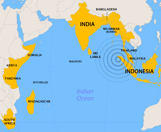
Countries affected
- India
- Indonesia
- Malaysia
- Maldives
- Myanmar
- Somalia
- Sri Lanka
- Thailand
- Indirect: Finland
- Norway
Humanitarian response
- Classic Response
- Football for Hope
- Music for Relief
- Reach Out to Asia
- Rugby Aid
- Tsunami Relief Cardiff
- UK Radio Aid
- WaveAid
- World Cricket Tsunami Appeal
The 2004 Indian Ocean earthquake was initially documented as having a moment magnitude of 8.8. The United States Geological Survey has its estimate of 9.1. Hiroo Kanamori of the California Institute of Technology estimates that Mw 9.2 is best representative of the earthquake's size. More recent studies estimate the magnitude to be Mw 9.3. A 2016 study estimated the magnitude to be Mw 9.25, while a 2021 study revised its 2007 estimate of Mw 9.1 to a new magnitude of Mw 9.2.
The hypocentre of the main earthquake was approximately 160 km (100 mi) off the western coast of northern Sumatra, in the Indian Ocean just north of Simeulue island at a depth of 30 km (19 mi) below mean sea level (initially reported as 10 km or 6.2 mi). The northern section of the Sunda megathrust ruptured over a length of 1,300 km (810 mi). The earthquake (followed by the tsunami) was felt in Bangladesh, India, Malaysia, Myanmar, Thailand, Sri Lanka and the Maldives. Splay faults, or secondary "pop up faults", caused long, narrow parts of the seafloor to pop up in seconds. This quickly elevated the height and increased the speed of waves, destroying the nearby Indonesian town of Lhoknga.
Indonesia lies between the Pacific Ring of Fire along the north-eastern islands adjacent to New Guinea, and the Alpide belt that runs along the south and west from Sumatra, Java, Bali, Flores to Timor. The 2002 Sumatra earthquake is believed to have been a foreshock, preceding the main event by over two years.
Tsunami
The sudden vertical rise of the seabed by several metres during the earthquake displaced massive volumes of water, resulting in a tsunami that struck the coasts of the Indian Ocean. A tsunami that causes damage far away from its source is sometimes called a teletsunami and is much more likely to be produced by the vertical motion of the seabed than by horizontal motion.
The tsunami, like all the others, behaved differently in deep water than in shallow water. In deep ocean water, tsunami waves form only a low, broad hump, barely noticeable and harmless, which generally travels at the high speed of 500 to 1,000 km/h (310 to 620 mph); in shallow water near coastlines, a tsunami slows down to only tens of kilometres per hour but, in doing so, forms large destructive waves. Scientists investigating the damage in Aceh found evidence that the wave reached a height of 24 m (80 ft) when coming ashore along large stretches of the coastline, rising to 30 m (100 ft) in some areas when travelling inland. Radar satellites recorded the heights of tsunami waves in deep water: the maximum height was at 600 mm (2 ft) two hours after the earthquake, the first such observations ever made.
According to Tad Murty, vice-president of the Tsunami Society, the total energy of the tsunami waves was equivalent to about 5 megatons of TNT (21 PJ), which is more than twice the total explosive energy used during all of World War II (including the two atomic bombs) but still a couple of orders of magnitude less than the energy released in the earthquake itself. In many places, the waves reached as far as 2 km (1.2 mi) inland.
Because the 1,600 km (1,000 mi) fault affected by the earthquake was in a nearly north–south orientation, the greatest strength of the tsunami waves was in an east–west direction. Bangladesh, which lies at the northern end of the Bay of Bengal, had few casualties despite being a low-lying country relatively near the epicentre. It also benefited from the fact that the earthquake proceeded more slowly in the northern rupture zone, greatly reducing the energy of the water displacements in that region.
Coasts that have a landmass between them and the tsunami's location of origin are usually safe; however, tsunami waves can sometimes diffract around such landmasses. Thus, the state of Kerala was hit by the tsunami despite being on the western coast of India, and the western coast of Sri Lanka suffered substantial impacts. Distance alone was no guarantee of safety, as Somalia was hit harder than Bangladesh despite being much farther away.
Because of the distances involved, the tsunami took anywhere from fifteen minutes to seven hours to reach the coastlines. The northern regions of the Indonesian island of Sumatra were hit quickly, while Sri Lanka and the east coast of India were hit roughly 90 minutes to two hours later. Thailand was struck about two hours later despite being closer to the epicentre because the tsunami travelled more slowly in the shallow Andaman Sea off its western coast.
The tsunami was noticed as far as Struisbaai in South Africa, about 8,500 km (5,300 mi) away, where a 1.5-metre-high (5 ft) tide surged on shore about 16 hours after the earthquake. It took a relatively long time to reach Struisbaai at the southernmost point of Africa, probably because of the broad continental shelf off South Africa and because the tsunami would have followed the South African coast from east to west. The tsunami also reached Antarctica, where tidal gauges at Japan's Showa Base recorded oscillations of up to a metre (3 ft 3 in), with disturbances lasting a couple of days.
Some of the tsunami's energy escaped into the Pacific Ocean, where it produced small but measurable tsunamis along the western coasts of North and South America, typically around 200 to 400 mm (7.9 to 15.7 in). At Manzanillo, Mexico, a 2.6 m (8.5 ft) crest-to-trough tsunami was measured. As well, the tsunami was large enough to be detected in Vancouver, which puzzled many scientists, as the tsunamis measured in some parts of South America were larger than those measured in some parts of the Indian Ocean. It has been theorized that the tsunamis were focused and directed at long ranges by the mid-ocean ridges which run along the margins of the continental plates.
Early signs and warningsDespite a delay of up to several hours between the earthquake and the impact of the tsunami, nearly all of the victims were taken by surprise. There were no tsunami warning systems in the Indian Ocean to detect tsunamis or to warn the general population living around the ocean. Tsunami detection is difficult because while a tsunami is in deep water, it has little height and a network of sensors is needed to detect it.
Tsunamis are more frequent in the Pacific Ocean than in other oceans because of earthquakes in the "Ring of Fire". Although the extreme western edge of the Ring of Fire extends into the Indian Ocean (the point where the earthquake struck), no warning system exists in that ocean. Tsunamis there are relatively rare despite earthquakes being relatively frequent in Indonesia. The last major tsunami was caused by the 1883 eruption of Krakatoa. Not every earthquake produces large tsunamis: on 28 March 2005, a magnitude 8.7 earthquake hit roughly the same area of the Indian Ocean but did not result in a major tsunami.
The first warning sign of a possible tsunami is the earthquake itself. However, tsunamis can strike thousands of kilometres away where the earthquake is felt only weakly or not at all. Also, in the minutes preceding a tsunami strike, the sea sometimes recedes temporarily from the coast, which was observed on the eastern earthquake rupture zone such as the coastlines of Aceh, Phuket island and Khao Lak in Thailand, Penang island in Malaysia, and the Andaman and Nicobar islands. This rare sight reportedly induced people, especially children, to visit the coast to investigate and collect stranded fish on as much as 2.5 km (1.6 mi) of exposed beach, with fatal results. However, not all tsunamis cause this "disappearing sea" effect. In some cases, there are no warning signs at all: the sea will suddenly swell without retreating, surprising many people and giving them little time to flee.
Tsunami wave field in the Bay of Bengal an hour after the earthquake
One of the few coastal areas to evacuate ahead of the tsunami was on the Indonesian island of Simeulue, close to the epicentre. Island folklore recounted an earthquake and tsunami in 1907, and the islanders fled to inland hills after the initial shaking and before the tsunami struck. These tales and oral folklore from previous generations may have helped the survival of the inhabitants. On Maikhao Beach in north Phuket City, Thailand, a 10-year-old British tourist named Tilly Smith had studied tsunamis in geography at school and recognised the warning signs of the receding ocean and frothing bubbles. She and her parents warned others on the beach, which was evacuated safely. John Chroston, a biology teacher from Scotland, also recognised the signs at Kamala Bay north of Phuket, taking a busload of vacationers and locals to safety on higher ground.
Anthropologists had initially expected the aboriginal population of the Andaman Islands to be badly affected by the tsunami and even feared the already depopulated Onge tribe could have been wiped out. Many of the aboriginal tribes evacuated and suffered fewer casualties, however. Oral traditions developed from previous earthquakes helped the aboriginal tribes escape the tsunami. For example, the folklore of the Onges talks of "huge shaking of ground followed by high wall of water". Almost all of the Onge people seemed to have survived the tsunami.
Related events


Map
Sources: wikipedia.org, news.lv, nekropole.info, lenta.ru
No places assigned
Persons
| Name | ||
|---|---|---|
| 1 |  | Vladimirs Kuļiks |
| 2 |  | Viktors Para |
Adverts